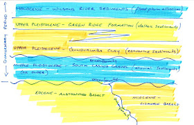
The best work done on the ‘recent’ sedimentary formations of the Wilsons River valley was a PhD thesis, Drury 1982. This was done as part of the then Water Resources Commission (now State Water) back when NSW government departments actually collected new information to guide future decision making (oops, there is a political comment in there). Drury 1982 was a huge thesis that provides a vast amount of information on the development of the Richmond Valley based mainly on the groundwater bores operating at the time supplemented by some (then) new drilling and geophysical techniques. To my knowledge no significant further published scientific assessment of the Quaternary sequences has occurred since Drury's thesis was written.
 |
| Cenozoic Stratigraphy of the Lismore area |
The Gundurimba Clay is a unit was formed during a period of relatively high sea level (higher than the present day) and warmer conditions. Shells were common but coral was found maybe indicating the idea that the area where the Gundarimba Clay was being deposited went through a warmer spell than we experience now. Drury 1982 identified pollen spores indicating the surrounding area was dominated by rainforest with some eucalypt forest too, in my mind this creates a picture that it was possibly a proto-‘Big Scrub’ low-land rainforest with the ‘Big Scrub’ proper forming after the next cold period at the beginning of the Holocene. However worth noting that the Upper Pleistocene is recognised around the world as starting off in a warm period turning into a glacial period with the last glacial maximum occurring around 22,000 years ago.
Drury 1982 demonstrated that preceding the deposition of the Gundurimba Clay there was a period of erosion meaning that the Gundurimba Clay unconformably overlies the South Casino Gravel. The South Casino gravel in turn uncomformably overlies the Cenozoic volcanic rocks of the Lismore and/or Alstonville Basalt. The South Casino gravel is at least Middle Pleistocene in age and is derived from the erosion of the underlying volcanics. Given its coarse nature it is highly permeable and is considered a good source of groundwater in other parts of the Richmond Valley but to my knowledge is rarely used in the Wilsons River area.
I'm probably trying to combine a lot into this one post so I'll have to tease out the details a bit more in future posts, especially that relating to the Gundurimba Clay and palaeo-environmental conditions which I know at least some of my blog readers have a keen interest in. At least I hope that this provides a starting point.
References/bibliography:
*Drury, L.W. 1982. Hydrogeology and Quaternary Stratigraphy of the Richmond River Valley, New South Wales: In Two Volumes. PhD thesis, University of New South Wales.
*Cotter, S. 1997. A Geochemical, Palaeomagnetic and Geomorphological Investigation of the Tertiary Volcanic Sequence of north eastern New South Wales. MSc thesis, Southern Cross University.
No comments:
Post a Comment