I came across this website selling T-shirts the other day. I can't believe I actually want to get one... or several.
http://www.localgeographic.com/t-shirts.phtm?cat=1
Reminds me of the worst geology joke I know:
What did one mountain say to the other mountain after the earthquake?
It wasn't my fault.
Tuesday 30 October 2012
Saturday 20 October 2012
Do you trust a geological map?
The NSW Geological Survey have produced the maps that we use today. They have recently placed all of them online for people to view which is... well... excellent! They can be found here. Some areas have excellent, up-to-date 1:100 000 scale maps which are exceptional. However, it is worth mentioning that the best scale you will find for most of the state is 1:250 000 older 1970's maps. These maps are good but they were mostly done through looking at aerial photographs with limited field checking and since nearly 40 years have passed our understanding of the rocks has changed and this means that geological maps can be misleading if you are not careful.
I recently had the opportunity to be involved in a project looking for
clay deposits in The Channon / Dunoon area. During
the project it became obvious that the geology was not what was mapped (to the left is the geology that was mapped in 1972). The investigation that I was lucky enought to be involved with was pretty simple it just involved an excavator digging a few holes in the ground (testpits). Importantly I had an experienced Engineering Geologist to show me what was going on.
Rock weathers to form soils but there is rarely a distinct boundary between soil and rock, a transition occurs. This transition zone is called the regolith which lies below the soil proper at the surface, it is the transition into saprolite (weathered rock) and then to unweathered rock. If the weathered rock was derived from shales, mudstones and other fine grained sediments then often these layers will become clay. It was this clay that was looked for.
What was done was to dig into the regolith and depending on the characteristics of the saprolite it would be possible to tell what the original rock would have been. From the mapping it was assumed that what we would find would be related to the Lismore Basalt or Kangaroo Creek Sandstone. What was found was neithers. Instead layers of clayey and silty material and bands of weathered coal were visible as well as lithic sandstone. Coal would certainly not occur in abundance in volcanic rocks like the Lismore Basalt and nor does it occur in the Kangaroo Creek Sandstone. Lithic sandstone is also absent from these units. What must have found was lots more of the Walloon Coal Measures.
From my understanding of the area around Dunoon and on the basis of what was found during the hole digging exercise I put together a rough new map of the area (the second map above). As you can see there is actually a fair amount of difference. So, don't take it for granted that when you look at a geological map it is exactly right. It should be used as a guide and your knowledge should be applied to check it. The amount of coal we found was so abundant that a discussion about this is probably worth another post in the future.
References/bibliography:
Brunker R.L., Cameron R.G., Tweedale G. and Reiser R., 1972, Tweed Heads 1:250 000 Geological Sheet SH/56-03, 1st edition, Geological Survey of New South Wales, Sydney
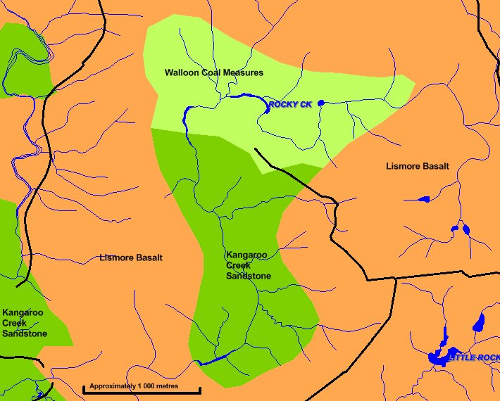 | |
| Geology according to the current published maps (after Brunker et al 1972)- scale approximate |
Rock weathers to form soils but there is rarely a distinct boundary between soil and rock, a transition occurs. This transition zone is called the regolith which lies below the soil proper at the surface, it is the transition into saprolite (weathered rock) and then to unweathered rock. If the weathered rock was derived from shales, mudstones and other fine grained sediments then often these layers will become clay. It was this clay that was looked for.
 |
| A better interpretation following the testpit investigation scale approximate |
From my understanding of the area around Dunoon and on the basis of what was found during the hole digging exercise I put together a rough new map of the area (the second map above). As you can see there is actually a fair amount of difference. So, don't take it for granted that when you look at a geological map it is exactly right. It should be used as a guide and your knowledge should be applied to check it. The amount of coal we found was so abundant that a discussion about this is probably worth another post in the future.
References/bibliography:
Brunker R.L., Cameron R.G., Tweedale G. and Reiser R., 1972, Tweed Heads 1:250 000 Geological Sheet SH/56-03, 1st edition, Geological Survey of New South Wales, Sydney
Monday 15 October 2012
Northern Rivers Geology Blog Update #2
It has been exactly one year since I started this blog. I have had around 15 000 page views over that time but strangely today, blogger has reset my statistics so I'm now in the dark about what was the most popular.
Thank you to everyone for your continuing visits and comments, thank you too to those that have made suggestions for improvements. I think the biggest thing is that I need to re-read what I have written before posting. My grammar and spelling can be shockingly bad! I also need to get to some long promised topics such as the Demon Fault, New England Granites and the Macley River valley.
Thanks again to all.
later edit: The statistics seem to be working again.
There has been about 15 800 pageviews
The most popular posts to date were:
Why you won't find CSG here now
Mythical geology at the mouth of the Tweed River
Walloon Coal Measures of the Southern Clarence-Moreton Basin
Geology in the air
The 'older' Rhyolite in the North East
The major referring sites were:
Google (Search Engine)
Wikipedia (Online Encyclopedia)
Clarence Valley Today (Blog)
Look and See New England (Blog)
Aussie Sapphire (Forum)
alas, about 10% of the page views seem to be bots but that is still nearly 15 000 page views.
Thursday 11 October 2012
How to emigrate from the Northern Rivers
Most people will be surprised that once, the Northern Rivers area was not east of the Great Dividing Range. It seems likely that there was a range which Ollier & Pain (1994) refer to as the Tasman Divide. This divide was originally speculated by Jones & Veevers (1983). This divide probably meant that rivers such as the modern day Clarence actually flowed to the west, indeed, if you had of stood on Cape Byron or looked out from the headlands of Port Macquarie you’d not see the wonderful blue ocean but land and possibly hills with the sea located possibly many hundreds of kilometres further away than today. I guess a good question to ask is where did all that land go?
 |
| Looking out to the Tasman Sea may have been looking out to another mountain range |
In short, the Australian continent was much bigger than it currently is with Zealandia being the eastern edge. Approximately greater than 80 million years ago (beginning in the Cretaceous period) something happened deep below the crust under the Tasman Divide, it seems that the convecting mantle was pulling the east coast of Australia in two different directions. The area of the future Australian Continent seemed to remain fairly stable but the west, the future Zealandia, was dragged to the east. This process split the continent in two and created a mid ocean spreading ridge. The Lord Howe Rise part of Zelandia was dragged and stretched, creating huge Horst and Graben fault systems and consequently many basins. The effect of stretching and faulting thinned the Lord Howe Rises Continental Crust which meant that it began to sink below sea level.
It is unknown whether the action of the convecting mantle may have been directly associated with the hotspot/hotspots associated with the Cenozoic volcanics such as those of the Tweed Volcano and Ebor Volcano as well as Lord Howe Island itself. One thing is clear though, is that as crust thinned it would increase the ability for molten rock to approach the surface and create volcanoes. Many of the areas in the Northern Rivers such as the Central Volcanic Province, Alstonville Basalt, Maybole Volcanics etc are seem to be in some way related to this episode of rifting instead of the later hotspot volcanoes. Indeed even the latest research such as Sutherland et al (2012) can't easily fit the ages of this volcanism into a traditional hotspot model.
If you look at a bathymetric map of our coastline you will see that the continental shelf is very thin in comparison to the rest of the world. It is also very abrupt, and this structure also points to the process of rifting that occurred during the late Cretaceous and early Cenozoic. The Tasman sea was the result of all this rifting and turmoil. It seems that the Zealandia just wanted to emigrate from the Australian continent. Sometimes I feel the same with our region including the wonderful New England region, I often think that we’d be better off if we were not part of New South Wales but a separate state but hopefully we don’t need to the extreme of rifting this part of the continent away to do it. A new state is, of course, politics and so I should probably end there.
References/Bibliography:
*Jones, J.G. & Veevers, J.J. 1983. Mesozoic origins & antecedents of Australias eastern highlands. Journal of the Geological Society of Australia V30.
*Ollier, C.D. & Pain, C.F. 1994. Landscape evolution and tectonics in southeastern Australia. AGSO Journal of Geology & Geophysics V15.
*Sutherland, F.L., Graham, I.T., Meffre, S., Zwingmann, H. & Pogson, R.E. 2012. Passive-margin prolonged volcanism, Eastern Australian Plate: Outbursts, progressions, plate controls and suggested causes. Australian Journal of Earth Sciences V59.
Saturday 6 October 2012
The New England tablelands seem to be upside down
The geomorphology of the Northern Rivers and New England region can be quite complex. There are many features around the region that have developed as a direct result of the underlying geology. Whether it be the great escarpment, the Ebor Volcano, the backward Clarence River or various other situations, there is always a geological reason for the landscape we see today. In a previous post on the Maybole Volcano near Guyra I quickly mentioned that there is an “inverted topography” which has been created following the deposition of the lava from this volcanic area. Maybole is not isolated in this situation, indeed according to Coenraads & Ollier (1992) much of the basalts in the New England region from Armidale, Walcha, Llangothlin and even places on the other side of the watershed and great dividing range of the Northern Rivers such as Nundle or Inverell show what is technically referred to as relief inversion.
The area around Armidale is actually a good example of the relief inversion, as most hills actually demonstrate the situation nicely. Take, for example, the hill that the University of New England is situated on. The Hill is capped with Cenozoic (Miocene) aged calc-alkaline olivine basalt (part of the Central Volcanic Province) just to the east of the hill (in the paddock below the university carparks) below the level of the lowest basalt flow is a fossil soil horizon, known as a palaeosol. This palaeosol has been affected by lava being deposited on it and has been turned into a material known as silcrete (soil which has been cemented with silica). The old soil was developed on rocks of the Carboniferous aged Sandon Beds. The Sandon Beds outcrop on the lower slopes and in the valleys in and around Armidale but once they were the hills themselves.
The basalts were erupted to the surface the chemical composition of the lava meant that they were quite low in viscosity, that is it was very liquid and consequently the lavas flowed down the valleys that existed at the time. The valleys tended to fill up to varying degrees, leaving only a thin layer of volcanic rock on the existing hill crests of the Sandon Beds or none at all. In the following millions of years the process of erosion would be more effective on the non-volcanic rock and the hills would eventually become incised, turning into gullies and eventually larger valleys. The basalt in the old valleys would remain relatively un-eroded and be become the modern hills.
Evidence of this process can be seen from historic mining of some of the gold around Armidale. The ‘old timers’ would dig under the basalt along ‘deep leads’ which were originally gravel and sand deposits associated with old creeks and rivers. These deep leads had been alluvial gold deposits preserved by the basalt flows. Many of these were mined in the 1800’s and early 1900’s in many areas of the New England district including one quite recently in the Tilbuster area (Ashley & Cook 1988). The silcrete deposits mentioned previously are also examples of the process.
References/bibliography:
*Ashley, P.M. & Cook, N.D.J. 1988. Geology of the Whybatong gold prospect and associated Tertiary deep lead, Puddledock, Armidale District. New England Orogen - Tectonics and Metallogenesis. Conference Papers presented at the University of New England.
*Coenraads, R.R. & Ollier, C.D. 1992. Tectonics and Landforms of the New England Region. 1992 Field Conference - New England District. Geological Society of Australia Queensland Division.
Subscribe to:
Posts (Atom)