There has been an increase in our understanding of the Clarence-Moreton Basin in recent years. The central upper portions of the basin have had several cored and un-cored boreholes drilled during exploration for natural gas, especially Coal Seam Gas. In this post, I will cover the implications of this exploration on our understanding of the Kangaroo Creek Sandstone and the recognition of another previously unknown unit.
In a previous post I described the Kangaroo Creek Sandstone. This unit was identified as a formation directly overlying the Walloon Coal Measures (and the MacLean Sandstone Member of the Walloon Coal Measures) (McElroy 1963). However, a recent paper (Doig & Stanmore 2012) attempts to resolve newly identified characteristics which have resulted in the authors proposing the creation of a new formation called the Orara Formation. It is proposed by Doig & Stanmore (2012) that the Orara Formation is comprised of two member units. These are another new unit called the Bungawalbin Member and the now demoted Kangaroo Creek Sandstone Member.
Doig & Stanmore (2012) found that the proposed Bungawalbin Member differed substantially from the Kangaroo Creek Sandstone and overlying Grafton Formation. They describe the Bungawalbin as between 45m-115m thick and dominated by mudstone and carbonaceous mudstone that is thinly bedded with fine grained sandstone with increasing amounts of massive, medium-grained quartzose sandstone beds near the base of the member. The unit is interpreted as a persistent low energy riverine floodplain environment.
The Bungawalbin Members contact with the underlying Kangaroo Creek Sandstone Member is transitional. With the medium-grained quartz rich sandstone becoming dominant in the Kangaroo Creek Sandstone. The composition and formation history of the Kangaroo Creek Sandstone has not been questioned but the significant fine grained component of the Bungawalbin Member necessitates the distinction between these two members. Additionally, Doig & Stanmore (2012) clearly demonstrated that the geophysical response of the Bungawalbin Member was substantially different from the Kangaroo Creek Sandstone.
Hence, we are learning more about the land on which we live. The geology is slowly becoming better understood. It is interesting to observe that there has been no detailed work on the upper most formations of the Clarence-Moreton since the 1960’s. The drilling that has occurred has unlocked more hidden characteristics of the basin. It helps our understanding of basin history as well as the original intention of finding gas resources. There is more to cover in future posts including understanding of the basins youngest formation, the Grafton Formation, but that will come soon.
References/bibliography:
*Doig, A. & Stanmore, P. 2012. The Clarence-Moreton Basin in New South Wales: geology, stratigraphy and coal seam gas characteristics. Paper presented at the Eastern Australasian Basin Symposium IV. Brisbane.
*McElroy, C.T., 1963. The Geology of the Clarence-Moreton Basin. Memoirs of the Geological Survey of New South Wales, Geology. 9.
A view of the geology of the Northern Rivers of New England, New South Wales. Includes thoughts on the formation of the regions volcanoes (Mount Warning, Ebor and others), groundwater, the Clarence Moreton Basin, recent sedimentation, gas (including coal seam gas), mineralization in the eastern part of the southern New England Orogen and more. What is the geological influence in the Northern Rivers and New England areas of Australia that provide us with the beauty and diversity we see today?
Sunday, 6 July 2014
Tuesday, 1 July 2014
On the Rocks
Three of the four in my family has been hit by the Flu. The only one that thankfully doesn't have it is the newborn. I hope he doesn't get it. Now, I wish I had taken that free flu-shot that my work offered me this year! I've infected most of the family! Obviously this means that original blog posts are going to be a bit light on for a little while. So, in the mean time I can recommend some interesting bits and pieces on the internet.
Today Wangiwriter presented a very interesting blog post on some of the rocks of the Newcastle area, part of the Sydney Basin. The pictures are lovely and Wangiwriter tells an interesting story. I know this is a bit out of the usual subject area but the piece is worth a good look. I've been to Catherine Hill Bay and loved the scenery. The geology was typical of a section of the Permian aged Sydney Basin but well exposed and situated in a stunning historical landscape. The conglomerate shown so well in Wangiwriters photographs are part of the Newcastle Coal Measures. Specifically, they are either part of the Moon Island Beach Formation or the Boolarroo Formation. I don't know Newcastle geology well enough to know exactly which.
Thanks to everyone that has been supporting my blog. I've noticed an increase in my advertising revenue of late. Now I'm up to at least a cup of coffee a week! I'm amazed at the value of some advertising clicks. Some earn more than $1, others just a few cents. I got excited when I see that Google payed my almost $1.70 for one click. I wonder what that advertisement was! I'll never know because Google handles all the advertising in the background.
![]() |
| On the Rocks with Wangiwriter - Catherine Hill Bay |
Thanks to everyone that has been supporting my blog. I've noticed an increase in my advertising revenue of late. Now I'm up to at least a cup of coffee a week! I'm amazed at the value of some advertising clicks. Some earn more than $1, others just a few cents. I got excited when I see that Google payed my almost $1.70 for one click. I wonder what that advertisement was! I'll never know because Google handles all the advertising in the background.
Labels:
opinion,
permian,
sedimentology
Location:
New South Wales, Australia
Tuesday, 24 June 2014
Earth Learning Idea
I have recently come across an interesting and easy to understand site that explains earth processes in fun and creative ways. This is a site called Earth Learning Idea. By way of examples here is a demonstration of sink holes that you can try yourself (just like those I mention in the addendum to this earlier blog post):
http://www.earthlearningidea.com/PDF/185_Sink_hole.pdf.
I'm pleased to see such an interesting site. It made me wonder whether I should be more pro-active in earth science education. Recently helping to sort out a rock collection for a local environmental centre is something that I enjoyed. I've also been honoured by an invitation to do a formal presentation at this years Big Scrub Rainforest Day. I'm happy to do these things because I enjoy geology and I enjoy talking with people.
Interestingly, as a member of the Geological Society of Australia I can be more formally aligned with geology education by joining the Specialist Group in Geological Education. I just don't want to stretch myself too far as I'm already a member of three specialist groups: the Environmental Engineering and Hydrogeology Specialist Group, Specialist Group in Geochemisty, Mineralogy and Petrology and the Specialist Group in Vocanology (Learned Australasian Volcanology Association). I have another 6 months to decide... I think it is good to take time in making decision... even if this is a little one.
http://www.earthlearningidea.com/PDF/185_Sink_hole.pdf.
I'm pleased to see such an interesting site. It made me wonder whether I should be more pro-active in earth science education. Recently helping to sort out a rock collection for a local environmental centre is something that I enjoyed. I've also been honoured by an invitation to do a formal presentation at this years Big Scrub Rainforest Day. I'm happy to do these things because I enjoy geology and I enjoy talking with people.
Interestingly, as a member of the Geological Society of Australia I can be more formally aligned with geology education by joining the Specialist Group in Geological Education. I just don't want to stretch myself too far as I'm already a member of three specialist groups: the Environmental Engineering and Hydrogeology Specialist Group, Specialist Group in Geochemisty, Mineralogy and Petrology and the Specialist Group in Vocanology (Learned Australasian Volcanology Association). I have another 6 months to decide... I think it is good to take time in making decision... even if this is a little one.
Labels:
opinion
Saturday, 7 June 2014
Blog Update #5
It has been about a year since my last blog update. I'm pleased with how well the blog is ticking along though I've been a bit slow in posting sometimes and I am still neglecting many areas. The area between Camden Haven and Coffs Harbour is regularly neglected, so too the New England highlands. I also tend to leave at least one typo per post! Not for the first time I will try and remedy these issues in future posts.
The next few months will have a focus on several areas:
While I'm looking both backward and forward. I'm looking forward to reaching 100 000 page views in the next few months. At the time of this post there were over 85 000 views though I estimate approximately 20% of these are not human visitors.
I'm also looking forward to the pocket money this blog is now helping me with. Visitors will notice advertising in the top right corner of the page. When visitors click on these ads I receive between 1cent and 80cents from Google. These ads are not ones that I choose but are placed by Google Adsense based upon the content of this page and your own Google search history. So far I've noticed ads for fracking companies, TAFE and universities and even Clive Palmers Australia Party! I've had advertising for about 2 months now and I've made enough for about 4 cups of coffee. How exciting!
Thanks to everyone for continuing to visit and comment. I appreciate comments and try to respond to all of them.
The next few months will have a focus on several areas:
- Continuing on the hydrogeology theme;
- Points of interest in the Macleay River catchment;
- The Mount Warning Central Complex;
- Recent reviews of the upper stratigraphy of the Clarence-Moreton Basin;
- Some more posts on gas resources; and
- A granite intrusion or two in the New England tablelands
While I'm looking both backward and forward. I'm looking forward to reaching 100 000 page views in the next few months. At the time of this post there were over 85 000 views though I estimate approximately 20% of these are not human visitors.
I'm also looking forward to the pocket money this blog is now helping me with. Visitors will notice advertising in the top right corner of the page. When visitors click on these ads I receive between 1cent and 80cents from Google. These ads are not ones that I choose but are placed by Google Adsense based upon the content of this page and your own Google search history. So far I've noticed ads for fracking companies, TAFE and universities and even Clive Palmers Australia Party! I've had advertising for about 2 months now and I've made enough for about 4 cups of coffee. How exciting!
Thanks to everyone for continuing to visit and comment. I appreciate comments and try to respond to all of them.
Labels:
opinion
Sunday, 1 June 2014
This is what one aquifer looks like
In some amazing places you can immerse yourself in an aquifer. These places are rare and dominated by a rock type that does not occur in any substantial amounts in our region. However, people dive in the sub-terrainian waters of the limestone caves of the Nullabour in South Australia. The best aquifers in our region do not contain large caves compared with limestone areas. They are hosted in riverine alluvial sediments, fossil soil horizons in volcanic rocks, or fractures in hard metamorphic and volcanic environments. The main aquifers being on the coastal river flood plains, Alstonville Basalt and the New England areas respectively. However, volumetrically the sources that are very large are those in coastal sands.
This post is an illustration of how one of those coastal sands aquifers looks. I've covered the Woodburn Sands in several previous posts but a quick summary is still needed. The Woodburn Sands are beach and dune sand that was laid down during the last significant interglacial. This was around 130 000 years ago during the Pleistocene period. The sea level was much higher than now and this meant that beach systems were often formed a significant way inland.
From the picture you can actually see what the medium that hosts an aquifer looks like. The Woodburn Sands are just that, sands. The sand grains are mostly quartz but there are also some grains made from volcanic and metamorphic rock fragments. Occasionally you can see grains of heavier minerals that were mined until the 1980's. The sand grains are very similar in size which is typical of wave and wind sorting. There is a very small fine fraction of clayey material.
Where the clay content is higher the ability of the water to flow through the aquifer is reduced. This is why some bores can only produce a small amount of water compared to the huge volume that is in the whole aquifer. This is an example of why aquifers tend not to behave as underground lakes. You can pump water out of one end and run out because the hydraulic conductivity (flow velocity) is not high enough to allow the water at the other end of the aquifer to flow in.
The Woodburn Sands is not the only important coastal sands aquifer in the region. Another very important water source include the Macleay sand coastal aquifers. These aquifers were formed in a similar way to the Woodburn Sands and are used for similar purposes. Usage includes irrigation, stock, domestic use and town water supply for places such as Kempsey and Evans Head. There are also some interesting arsenic contamination issues in one aquifer system (Stuarts Point) in the Macleay area which I will post on in the near future.
The similar characteristics of the coastal sands aquifer systems in the North Coast area has motivated the NSW state government to develop a Water Sharing Plan for these systems as a whole. The Water Sharing Plan is expected to be formally adopted this year (2014). Local governments regard groundwater from the coastal sands aquifers as very important. Rous Water has recently adopted its future water strategy which identifies coastal sands as the main source of additional information in the medium to long term and Mid-coast water have recently increased their production of groundwater for drinking too.
Available here is a presentation by the NSW Office of Water on the overall coastal sands systems in North East New South Wales
| Auger containing saturated sand from the Woodburn Sands |
From the picture you can actually see what the medium that hosts an aquifer looks like. The Woodburn Sands are just that, sands. The sand grains are mostly quartz but there are also some grains made from volcanic and metamorphic rock fragments. Occasionally you can see grains of heavier minerals that were mined until the 1980's. The sand grains are very similar in size which is typical of wave and wind sorting. There is a very small fine fraction of clayey material.
Where the clay content is higher the ability of the water to flow through the aquifer is reduced. This is why some bores can only produce a small amount of water compared to the huge volume that is in the whole aquifer. This is an example of why aquifers tend not to behave as underground lakes. You can pump water out of one end and run out because the hydraulic conductivity (flow velocity) is not high enough to allow the water at the other end of the aquifer to flow in.
The Woodburn Sands is not the only important coastal sands aquifer in the region. Another very important water source include the Macleay sand coastal aquifers. These aquifers were formed in a similar way to the Woodburn Sands and are used for similar purposes. Usage includes irrigation, stock, domestic use and town water supply for places such as Kempsey and Evans Head. There are also some interesting arsenic contamination issues in one aquifer system (Stuarts Point) in the Macleay area which I will post on in the near future.
The similar characteristics of the coastal sands aquifer systems in the North Coast area has motivated the NSW state government to develop a Water Sharing Plan for these systems as a whole. The Water Sharing Plan is expected to be formally adopted this year (2014). Local governments regard groundwater from the coastal sands aquifers as very important. Rous Water has recently adopted its future water strategy which identifies coastal sands as the main source of additional information in the medium to long term and Mid-coast water have recently increased their production of groundwater for drinking too.
Available here is a presentation by the NSW Office of Water on the overall coastal sands systems in North East New South Wales
Monday, 19 May 2014
Geology, stratigraphy, water and CSG a bit more understood
A CSIRO researcher recently provided me with a copy of a conference paper on the Clarence-Moreton Basin that I have been searching for (Doig & Stanmore 2012). I was looking for this information for quite some time as I thought there was much to be learned from it. This is because the research was based upon coal seam gas (CSG) exploration results. It did not disappoint me at all. I have previously blogged on the stratigraphy of the basin but frequent visitors will be aware that there has been a hiatus on this topic. This is because I knew more information had been compiled as a result of gas exploration in the region. In particular this was to do with the Grafton Formation and Kangaroo Creek Sandstone. You can read my previous posts but note that Doig & Stanmore (2012) propose to reclassify these units (see figures 1 and 2 on this post). The information my previous posts were based upon Wells and O’Brien (1994). This is still the most comprehensive guide to the basin but now there is potentially some significant refinements.
Doig & Stanmore (2012) noted that CSG exploration drilling has provided important clues to the layers that make up the Clarence-Moreton basin that were inferred only through limited field exposure. Drilling provides a nice continuous profile which can be compared to other drill holes and to outcropping information. In the case of Doig & Stanmore (2012) this has completely redrawn the stratigraphy of the upper Clarence-Moreton Basin.
I will go into more detail in future posts but I note that Doig & Stanmore (2012) have made some major changes to the Grafton Formation. In particular, they have identified two new distinct members of the formation. The Piora Member and the Rappville Member. As for the underlying Kangaroo Creek Sandstone, this spatially and significant unit has been demoted simply to a member of a newly proposed formation called the Orara Formation. The Orara Formation itself has two distinct formations the demoted Kangaroo Creek Sandstone Member and the new Bungawalbin Member. (See figure 2).
The Woodenbong beds don’t get a guernsey at all in this paper. I suspect that this is because it would better fit into either the Bungawalbin Member of the Kangaroo Creek Sandstone or the Piora Member of the Grafton formation. More work needs to be carried out to make it more certain.
Clearly we do not understand much about the Clarence-Moreton Basin. Even the shallowest geological components! Knowledge keeps improving the more people investigate. The paper provides further interest because identification of the stratigraphic units and geochemical data obtained provide an indication of the risk associated with groundwater resources and CSG production. So as usual, further blog posts are required.
References/bibliography:
*Doig, A. & Stanmore, P. (2012). The Clarence-Moreton Basin in New South Wales; geology, stratigraphy and coal seam gas characteristics. Paper presented at the Eastern Australian Basins Symposium IV, Brisbane.
*Wells, A.T. & O’Brien (1994). Geology and Petroleum Potential of the Clarence-Moreton Basin, New South Wales and Queensland, Australian Geological Survey Organisation, Bulletin 241.
![]() |
| Interpretation of the stratigraphy of the upper sequences of the Clarence-Moreton Basin after Wells & O'Brien (1994) and Willis (1994) |
![]() |
| Reviewed Clarence-Moreton Basin stratigraphy after Doig & Stanmore (2012) |
The Woodenbong beds don’t get a guernsey at all in this paper. I suspect that this is because it would better fit into either the Bungawalbin Member of the Kangaroo Creek Sandstone or the Piora Member of the Grafton formation. More work needs to be carried out to make it more certain.
Clearly we do not understand much about the Clarence-Moreton Basin. Even the shallowest geological components! Knowledge keeps improving the more people investigate. The paper provides further interest because identification of the stratigraphic units and geochemical data obtained provide an indication of the risk associated with groundwater resources and CSG production. So as usual, further blog posts are required.
References/bibliography:
*Doig, A. & Stanmore, P. (2012). The Clarence-Moreton Basin in New South Wales; geology, stratigraphy and coal seam gas characteristics. Paper presented at the Eastern Australian Basins Symposium IV, Brisbane.
*Wells, A.T. & O’Brien (1994). Geology and Petroleum Potential of the Clarence-Moreton Basin, New South Wales and Queensland, Australian Geological Survey Organisation, Bulletin 241.
Tuesday, 6 May 2014
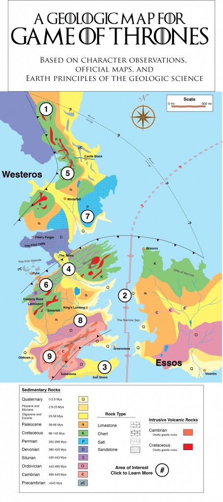
The Game of Thrones - Geological Map
Time again to delve into the region of geological fantasy. I have previously noticed that Middle-Earth from the J.R.R. Tolkien’s Lord of the Rings has had its climate modelled. But I’ve never seen anybody actually recreate a fantasy world’s geology, until now. Miles Traer and Mike Osborne from Stanford University has done just that. He has created a geological map and recreated the geologic history of the lands from the series Game of Thrones.I’ve only watched one episode of Game of Thrones myself. I found it a little to confronting and violent. Yet, the storyline was very good. I can see why people really like the series. Though I’m a little surprised that someone is obsessed enough to develop a geological history of the area.
Miles Traer’s blog on the geology of Westeros and Essos can be found here.
Mike Osborne’s account of the geology of the Game of Thrones lands can be found on the American Geophysical Union Blog here.
Subscribe to:
Posts (Atom)