 |
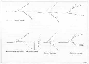
| From Ollier and Haworth (1995) The effect of uplift on a denritic drainage |
How did this come to be? Ollier and Haworth (1994) came up with a surprising solution. Essentially, they thought that the angles the tributaries were joining the Clarence would make sense if the Clarence River once flowed the opposite direction. Today this seems like a far fetched idea, I mean, water can’t run up hill, can it? But Ollier and Haworth (1994) thought that prior to the Cenozoic volcanoes that make up the Main Range, Focal Peak and Tweed Volcanoes the land surface would have been much flatter. Indeed the sediments closer to these volcanic centres has been uplifted by hundreds of metres. If there were no mountain ranges along the Queensland border it would be quite conceivable for a river to flow from the New England highlands northward into the Condamine River in Queensland and then into the Murray-Darling River system.
The current trace of the Clarence River is a little bit strange. In many places it crosses between hard Palaeozoic basement rock of the New England into the softer rock of the Clarence Morton Basin and then back again. Rivers usually cut river channels preferentially into softer rock and will rarely flow from gentle valleys in softer rock into steep hard valleys as the Clarence River does along its southward path. Combining this with the knowledge that parts of the Clarence Morton Basin have been shown through various seismic exploration techniques that is has been warped in various directions adds further to the argument.
I for one, am convinced. I think that the Clarence River once flowed north before the Macpherson Range came into existence and the River would probably have joined with an earlier Condamine River. Need to check for yourself? Have a look at the rivers of the region on a map, follow the route of the Clarence River from the Pacific ocean and observe the rivers that join in. Surprisingly, you might find it makes sense!
Postscript: Still can't picture the Clarence River flowing inland? This post discusses the location of the Great Australian Divide and where it would have been when the Clarence River flowed into the Murray-Darling/Condamine System.
References/Bibliography:
*Ollier, C., Haworth, R.J. (1994) Geomorphology of the Clarence-Moreton Basin. In Wells, A.T. & O’Brian, P.E. Geology and Petroleum Potential of the Clarence-Morton Basin. Australian Geological Survey Organisation, Bulletin 241.
I am fascinated with, and sometimes find it difficult to comprehend, the direction rivers run, as we travel around. Very interesting.
ReplyDeleteThanks for visiting Jan.
ReplyDeleteI've visited your blog and see you've seen a lot of rivers. I wish I got the chance to visit a few more.
Great post Rod. Had alook at a map and it does make a lot of sense.
ReplyDeleteHi Mark, It does make you pull out the maps doesn't it!
ReplyDeleteIt is surprising what shapes you can find in drainage patterns that tell you a lot about the land under it. I've seen zig-zag rivers in aerial photographs up in the New England area too, probably due to two different faulting episodes creating two sets of parallel faults which are oblique to each other... if that makes sense.
Geology is far more fascinating than I had thought, piecing history and natural sciences together. Some very interesting thoughts here Rod. Makes one want to know more.
ReplyDeleteThanks for leaving a thoughtful comment on my blog, hopefully you'll be able to enjoy the photos next time as well.
Hello,
ReplyDeleteI am hoping that you might be able to help me with some research I ahve been doing. I am looking for aboriginal engravings around the Copmanhurst area and I wonder if you encoutered any in this area whilst you were working with the legendary Isabel McBryde? I have done extensive cavign in this area and believe I have found quite a few areas of interest but I also believe I have missed the majority. Thankyou Kelly.. my email is kellybeneke@hotmail.com
I'm afraid, I've never worked with Isabel and my knowledge of indigenous engravings is incredibly limited. Sorry I can't help. Good luck in your research - it sounds like a tricky but interesting area of investigation.
DeleteHi Rod,
ReplyDeleteI've had a great deal of fun exploring this blog and will do over the coming weeks. However this particular post caught my attention.
As a undergrad in the 90s with an interest in paleogeography I wrote what could endearingly and probably inaccurately described as a "pre-thesis" on the reverse rivers of SE Qld/NE NSW.
My pet theory was that there may have been a decent-sized river also flowing from the Tyalgum area in a NWly direction. This was based on the dip in the volcanics around the area in relation to their position above sea level - similar to the idea of a plaster cast. Don't ask me to recall too much more - I cannot remember whether my supervisor had any time for this theory and/or whether it was formed with any real depth of thought. Of course movement of the crust is far more dynamic than that simple assessment, but I still wonder if there was anything in it.
I obviously never went on with the lucrative (ahem) field of paleogeography and dedicated myself to the slightly less lucrative (double ahem) field of cartography.
Hi Matt,
DeleteThe details seem fascinating. Pre-Cenozoic volcanics (i.e. Mount Warning/Mount Barney etc - about 20-30Ma), I think that idea is very reasonable. It is even more so pre-Tasman Sea break-up (70-80Ma). Another lost tributary of the Condimine River sounds intriguing.
During the Cenozoic volcanism if such a river system already existed then it is possible it persisted for some time. The Wilsons River might be a good example as it actually seems to demonstrate that it flowed westward prior to the volcanism. This is because it still does flow to the west for much of its journey.
Another lead might be the Chingee Conglomerate just over the border. It is possible that this unit may provide evidence for or against your hypothesis. There are a lot of interesting possibilities.
Did you keep your interest up in palaeogeography?
Didn't really keep up with it too much Rod, but it still piques my interest.
ReplyDeleteI've long lost the copy with my musings, but I believe that using the same "plaster mould" theory you could hypothesize that the river at one stage flowed out somewhere just south of Beaudesert (due to the elevations at which the Lamington group basalts are found there - the lava would possibly have flowed down the "lost river") and west towards the Condamine. Of course, the course of any such river would likely flucuate over time and from memory I also hypothesized that the upthrusting (for want of a more accurate term) of the Richmond Horst (late Cretaceous from memory??) may have played a part in changing it's course to flow eastward and perhaps even play a part in the erosion of the current path of the Brisbane & Logan Rivers through the Neranleigh-Fernvale beds.
Probably pie in the sky stuff though but fun to wonder about! Again this is from nearly 20 years, so my memory is a little hazy.
From what I've seen lately it is rare for researchers these days to come up with good hypotheses and then try and actively find new knowledge of the landscape to prove it. So often, people just review old information and come up with new interpretations... Just getting a little bit of new knowledge makes reinterpretation useful, otherwise it is just spinning around and around! It sounds like it wound have been a great project... and still would be!
DeleteHaving a cartography background (I guess that is mostly GIS these days) you'd probably be in a good position to revisit the geographic features of the area. Putting together some palaeo-surface models and then accounting for known deformation during the Mesozoic and Cenozoic would be interesting and challenging!
So much to learn about the land and so little time to learn it.
Finding a Murray Cod in the Guy Fawkes River (tributary to the Clarence), the question arose: How did these fish get over the Great Dividing Range? Makes me think that all these rivers ran eastward into the Murray, before the mountain range rose and divided the watershed.
ReplyDelete