Wednesday, 15 February 2012

Take yourselves on a tour

Bob and Nancy are experienced geologists from Armidale who have developed a range of free self guided tours for many parts of Australia and New Zealand. At the time of this post most focus on the northern parts of New South Wales and New England but continues to expand.

Bob and Nancy's Brooms Head Tour Map
Their tour home page can be found here:
http://ozgeotours.110mb.com/index.html
or alternatively on their business site here:
http://brovey.yolasite.com/free-self-drive-geological-tours.php

I do recommend having a good look to see what is close to you or what would be worth looking at if you are traveling to other parts of the country or even to New Zealand. Bob and Nancy have done an exceptional job of developing these tour guides. They are easy to read, understand and follow.  In my view there is nothing like it available elsewhere on the web.

At the time of this blog post tours that are directly relevant to the Northern Rivers of the New England Region are: (directly linking to the PDF document from Bob and Nancy's site)

Wednesday, 8 February 2012

Lots of heat but low pressure between Ebor and Guyra

In the headwaters of the Aberfoyle and Guy Fawkes Rivers, tributaries of the Clarence River lies a rare zone (for Australia) of rocks that have experienced high temperatures but surprisingly low pressure. This is another one of those “we don’t have a clear answer” posts, in particular what has actually caused the metamorphism of the rock in this area, but research just published in January (Craven et al. 2012) has shed a lot of light on the matter.

Originally it was thought that the metamorphism at Wongwibinda (The Wongwibinda Metamorphic Complex) was directly associated with the emplacement of the Granites since the most intensely metamorphosed rocks are close to the Permian aged Abroi Granodiorite and other Permian granites with a decrease in intensity of metamorphism further away from these intrusions (Wilkinson 1969). The depth of metamorphism was never considered very deep because the minerals that are present in the metamorphic rocks are not formed where intense compression is found. However, it has since been observed that contacts with some of the granites shows no or little metamorphic effects, notably along the contact with the southern part of the Abroi Granodiorite. Additionally, the Abroi Granodiorite itself displays some metamorphic textures making the picture relatively unclear.

An old geological map of the area (NSW Geological Survey)-
Note that the Glen Bluff fault should not define the edge of the schist (gradational)
(Phag - Abroi, Plr - Ramspeck, Pl - Girrakool and Dyambarin, Tb - Basalt)
Like many parts of the New England, the geology can be quite complex with many aspects and relationships not fully understood and this holds for the Wongwibinda area which is a area of metamorphism, abundant faulting, granite intrusions, deep sea sedimentary and volcaniclasitic rocks and basalt lavas. Describing the generalgeology may be easiest from east to west. Before coming to the properties of Abroi and Springfield is the Palaeozoic aged Dyambarin Beds which is neatly faulted off to the east. The eastern side of the Wongwibinda Fault lies rock of the Abroi Grandiorite (a type of granite), sometimes referred to as the Abroi Gneiss (in this case metamorphosed granite which appears to have been affected by the Wongwibinda Fault). Then just to the west of this we enter what is significantly altered Girrakool Beds and this is were it gets even more interesting.

The eastern most part of the Girrakool beds has been significantly affected by heat maybe up to about 700 degrees Celsius, but has experienced very low pressures and this has created an unusual texture called migmatite. Migmatite is a type of rock were the parent (in this case sandstone and mudstone sedimentary rocks of the Girrakool Beds) has been heated so much that it just starts to become liquid like, here it also shows Ptygmatic folding. The liquid usually accumulates or is formed in some individual layers creating essentially layers of molten rock between sediments. Sometimes the hot liquid rock follows cracks in the rocks creating little dyke like structures too.

Moving further to the west we enter a zone of schist (called the Rampsbeck Schist), which is a medium grade metamorphic rock that has had some of the crystals in the rock reform into layers, this schist extends further west showing less and less metamorphic effects until it is indistinguishable from the rest of the Girrakool Beds. There are also some areas of quartzite and amphibolite (other metamorphic rocks) in the schist zone. I’ve also seen a pegmatite dyke a bit further to the west, which I have no idea where it fits into the picture.

Over the top of all this are remnants of comparatively recent Basalt referred to as Tertiary (or Mid-Cenozoic aged) Alkali Basalt. Given its location this basalt is probably Doughboy Basalt, part of the Cenozoic aged (~40Ma) Doughboy Volcanic Province.

But what caused the formation of the metamorphism? Many mechanisms have been proposed by different authors such as Wilkinson (1969), Danis et al (2010) and Craven et al (2012) and other authors. Craven (2012) has carried much work, including dating to try and gain an understanding:
  • Was it the Wongwibinda fault? No – otherwise the rock would pressure related textures. 
  • Was it the intrusion of the Abroi Granodiorite (or other granites in the area)? No – otherwise we’d see metamorphism around all the Abroi Granodiorite that we don’t see, and the age of the Abroi Granodiorite is older than the date of metamorphism. 
  • Was it an intrusion that we can’t see because it fairly deep underground? No – gravity surveys have been conducted and these don’t show any deep granites other than the Abroi Granodiorite in the area of maximum metamorphism.
  • Was it the eruption of the Cenozoic Basalts? No, the age of metamorphism vastly predates the Cenozoic period.

Wow, so what options are left? Craven et al (2012) have come up with a theory: following the tectonic events that formed the granites in the area there was a period of stretching of the earth, this thinned out the crust and allowed for heat to be more easily transferred from the mantle. All of the other options are more common elsewhere in Australia and around the world, but each option has been refuted by different evidence until the only reasonable explanation left at this stage is the extension of the crust to allow convective heat transfer from the mantle to very shallow levels during the Permian.

I seem to have lost my old photographs of the migmatite but I have found a good website on Finnish migmatites that has some great pictures. It can be linked to from here.

A follow up post on the Wongwibinda migmatites can be found here.

References/bibliography:

*Danis, C.R., Daczko, N.R., Lackie, M.A. and Craven, S.J. 2010. Retrograde metamorphism of the Wongwibinda Complex, New England Fold Belt and the implications of 2.5D subsurface geophysical structure for the metamorphic history. Australian Journal of Earth Sciences V57.
*Craven, S.J. Daczko, N.R. and Halpin, J.A., 2012. Thermal gradient and timing of high-T-low-P metamorphism in the Wongwibinda Metamorphic Complex, southern New England Orogen, Australia. Journal of Metamorphic Geology V30.
*Wilkinson, J.F.G. 1969 The New England Batholith - introduction. IN Packham G.H.(ed) - The geology of New South Wales. Geological Society of Australia. Journal V16.

Wednesday, 1 February 2012

The backward Clarence River

I’ve always wondered about a couple of the major rivers in our region and why the flow the direction they do. In particular I have been interested in the Richmond River and Wilsons River systems and also the Clarence Systems. I recently did a blog post on the Wilsons River and how along a large part of its length it seems to have flowed away from the sea for quite some time, maybe millions of years. In the comments on that post, Mark asked me why a tributary of the Clarence River seems to join that river in a peculiar way and that reminded me to do a post on the topic. So here it is.

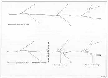
From Ollier and Haworth (1995) The effect of uplift on a denritic drainage
If you have a look at a map of the Clarence River system and its tributaries you will observe that the shape of the catchment is unusual. The major tributaries of the Clarence such as the Mann River, Orara River, Timbarra River, Boonoo Boonoo River and Cataract River flow north into the south flowing Clarence River. Usually the dendritic shape of river tributaries means that tributaries join with the main river at an acute angle. The major tributaries above, however, join at an obtuse angle. They almost look like they are flowing backwards.

How did this come to be? Ollier and Haworth (1994) came up with a surprising solution. Essentially, they thought that the angles the tributaries were joining the Clarence would make sense if the Clarence River once flowed the opposite direction. Today this seems like a far fetched idea, I mean, water can’t run up hill, can it? But Ollier and Haworth (1994) thought that prior to the Cenozoic volcanoes that make up the Main Range, Focal Peak and Tweed Volcanoes the land surface would have been much flatter. Indeed the sediments closer to these volcanic centres has been uplifted by hundreds of metres. If there were no mountain ranges along the Queensland border it would be quite conceivable for a river to flow from the New England highlands northward into the Condamine River in Queensland and then into the Murray-Darling River system.

The current trace of the Clarence River is a little bit strange. In many places it crosses between hard Palaeozoic basement rock of the New England into the softer rock of the Clarence Morton Basin and then back again. Rivers usually cut river channels preferentially into softer rock and will rarely flow from gentle valleys in softer rock into steep hard valleys as the Clarence River does along its southward path. Combining this with the knowledge that parts of the Clarence Morton Basin have been shown through various seismic exploration techniques that is has been warped in various directions adds further to the argument.

I for one, am convinced. I think that the Clarence River once flowed north before the Macpherson Range came into existence and the River would probably have joined with an earlier Condamine River. Need to check for yourself? Have a look at the rivers of the region on a map, follow the route of the Clarence River from the Pacific ocean and observe the rivers that join in. Surprisingly, you might find it makes sense!

Postscript: Still can't picture the Clarence River flowing inland? This post discusses the location of the Great Australian Divide and where it would have been when the Clarence River flowed into the Murray-Darling/Condamine System.

References/Bibliography:

*Ollier, C., Haworth, R.J. (1994) Geomorphology of the Clarence-Moreton Basin. In Wells, A.T. & O’Brian, P.E. Geology and Petroleum Potential of the Clarence-Morton Basin. Australian Geological Survey Organisation, Bulletin 241.

Thursday, 26 January 2012

How cold was it? Glaciers in New England?

I was very, very pleased to receive this comment by Bob (a physical geographer by ‘trade’) a bit more than a week ago. Bob posted the comment on my blog about Point Lookout and has been reproduced below:

"Rod,

You and your readers might be interested in a discovery made around Ebor and Guyra just last week, when I was working with a team of glacial buffs from UQ and UT. We found definite evidence of periglacial activity, presumably from the Last Glacial Maximum, ~20 000 years ago. The best examples were at Guyra on the slopes around Malpas Dam -- clear evidence of solifluction lobes, rock glaciers, snow hollows, and other freeze-thaw features, and what could only be described as incipient cirques -- ponds and bogs sapping back into the escarpment and probably still holding some snow in the frigid Guyra winters. The curious point is that they were between 1200 and 1300 metres, not at the highest points above 1500m where we were expecting them, but all on steep south facing escarpments.

One intriguing feature near Point Lookout, on the road up where it crosses the Little Styx River and at 1450m, was what looked very like a terminal moraine. This of course is a glacial, not a periglacial feature, so it is very hard to believe-but have a look at it, and see what you can make of it. There were at least 16 glacial cycles in the Pleistocene, so maybe one of them at least was really severe, and glaciated this far north. Otherwise, you have to go back to the Permian...

Bob H."


probable solifluction lobes and terraces on hill slope at Malpas Dam
This is exciting stuff to hear about because to my knowledge there is little or no evidence of cold climate landforms in the region. In fact I think the areas of the Tasmania are probably the only areas in Australia were these are frequent, though they have also been possibly identified in the Southern Alps and areas of Victoria. Certainly authors such as Petherick et al. (2011) and Hope (2005) did not identify such equivalent indicators of how far north such extreme cold could be detected. I understand that the cold climate landforms that Bob mentions have been found by researchers various universities such as from the University of Queensland, University of Technology, Sydney and the University of Tasmania. Acting on the tip off from Bob, I found an example of solifluction right on the northern side of Malpas Dam using Google Maps, this one is actually visible from the lookout on the southern side of the dam too (sorry about the quality of the photos, it was a long time since I took them and I didn’t realise what I was looking at that time). Get on Google maps and visit the dam yourself and have a look.

Same solifluction lobes visible south of the hill (same hill as picture above)
Solifluction is caused from the thawing of surface layers of permafrost during the summer leading to the thawed part of the soil profile slipping over the un-thawed permafrost and creating ‘lobes’ of soil. The cold climate structures that have been identified near Guyra are present on the southern side of the hill slopes where the sun was unable to melt much of the ice in the soil and therefore creates conditions of permafrost. Permafrost is not present anywhere on the Australian mainland today and demonstrates a significant change in climate has occurred (though those that know Guyra will still argue it is still uncomfortably cold there!).

What Bob appears to have found near point lookout is even more incredible, as a moraine is formed through the action of glaciers which are accumulations of ice on the surface that slowly moves through a landscape under the action of their own weight. Glaciers in Australia were thought to be limited to Tasmania and the Snowy Mountains. No doubt we will expect to see some published papers on the structure and context of these cold climate features in the region some time in the near future. I can't wait to read the published work that comes from this discovery. 

For further information on the individual cold climate features described above by Bob  visit the glossary, an online encyclopeadia or a good physical geography book such as Geosystems by Christopherson. If you are a little unclear about the locations of these sites and how they fit into a ‘Northern Rivers’ blog then it is worth mentioning this part of the New England, at Guyra and Malpas Dam are right at the head waters of the Gara River which is a tributary of the Macleay River that runs through Kempsey. The New England Highway in the Guyra area is pretty close to the actual crest of the catchments of the northern rivers, with the rivers to the west of it flowing into the Murray-Darling Basin and those to the east to the Pacific Ocean. Point Lookout is in the headwaters of the Bellinger River which runs trough Bellingen and is also part of the headwaters of the Macleay too.

References/Bibliography:

*Christopherson, R.W., 1997. Geosystems Wiley.
*Hope, P. 2005. The Weather and Climate of Australia During the Last Glacial Maximum. University of Melbourne, PhD Thesis, unpubl.
*Petherick, L.M., Moss, P.T & McGowan, H.A., 2011. Climatic and Environmental Variability During the Termination of the Last Glacial Stage in Coastal Eastern Australia: A Review. Australian Journal of Earth Science V.58.

Monday, 23 January 2012

More on the Tweed Volcano

I had the pleasure in obtaining a copy of a University of New England honours research thesis by Howden (2009) a week ago. For one thing, I'm pleased to see that there is still some research being conducted on the Tweed Volcano and Focal Peak Volcano, despite the state of our Country's university science faculties these days. Howden has put a great deal of effort into distinguishing between the mafic rocks of the volcano (basalts) including some detailed petrographic and geochemical analysis. One of the points of interest to me is the attempt to distinguish between the Blue Knob Basalt and Lismore Basalts, sadly, the work undertaken by Cotter (1998) was unavailable (lost to the world until recently) to her. This would have clarified some issues which were difficult to resolve in her thesis.

Previous authors such as Duggan & Mason (1978) noted that there appeared to be very little (if any) distinction between the Blue Knob and Lismore Basalts except for their apparent stratigraphic location. Duggan & Mason (1978) determined that the Blue Knob Basalt appeared to overlay the Nimbin Rhyolite and the Lismore Basalt under it. However, Duggan & Mason and other authors such as Smith & Houston (1995) suggested a possibility that the Blue Knob Basalt could actually be inter-collated with rhyolite flows indicating that it was possible that the basalts were really just occasionally interrupted by flows of the Nimbin Rhyolite.

Howden (2009) has through comprehensive geochemical and petrological study of the Lamington Volcanics demonstrated that the only way to distinguish between the two basalt units was on the basis of phenocryst size with the Blue Knob Basalt showing larger grains of plagioclase feldspar. In the absence of any other geochemical or petrological distinguishing characteristics this shows a very uninspiring difference between them, I would suggest, insufficient to say that they were in fact different.

Because of the absence of significant differentiating features it is likely that the Blue Knob Basalt is really just the Lismore Basalt which continued to erupt at various times with intervening periods of large rhyolitic eruptions of the Tweed Volcano. This means that this can be confirmed if flows of basaltic lava can be identified between rhyolite. In Queensland the equivalent of the Nimin Rhyolite, the Binna Burra Rhyolite shows intercollated flows of Hobwee Basalt (the equivalent of the Lismore Basalt). The plagioclase phenocryst grain size difference probably just reflects slightly different magma residence periods in the magma chamber becoming more obvious at the volcano became older. This is also demonstrated as the Hobwee Basalt in Queensland shows the upper flows have larger phenocrysts.

Slowly we are gaining a clearer picture of our present day landscape and the mechanisms that made it. Sometimes difference between the way we think they have occurred and they way we later find out seems quite minor, yet the implications are significant in understanding how the landscape actually behaves under the ground. The small areas of 'Blue Knob Basalt' were thought to be a last spurt of eruption of the Tweed Shied Volcano (either centred on present day Mount Warning, or other vents on the flanks of the volcano), I think that Howden (2009) has presented us with enough evidence how to say that the way the volcano formed included two different types of lavas (basalt and rhyolite) erupting at essentially the same time.

References/bibliography:

*Cotter, S. 1998. A Geochemical, Palaeomagnetic and Geomorphological Investigation of the Tertiary Volcanic Sequence of North Eastern New South Wales. Masters Thesis, Southern Cross University.
*Duggan, P.B., Mason, D.R. 1978. Stratigraphy of the Lamington Volcanics in Far Northeastern New South Wales. Australian Journal of Earth Sciences V25.

*Howden, S. 2009. An Evaluation of Mafic Extrusives Spatially Assoicated with the South-Western Aspect of the Tweed Shield Volcano, BSc(Hons.) thesis, University of New England, Armidale.
*Smith, J.V. , Houston, E.C. 1995. Structure of lava flows of the Nimbin Rhyolite, northeast New South Wales. Australian Journal of Earth Sciences V42(1) p69-74.

Saturday, 14 January 2012

Monday, 9 January 2012

A westward Wilsons River

The Wilsons River flows from east to west between Booyong and Lismore which is unusual for coastal rivers in the region. You’d expect a river to find the path of least resistance and head to the sea quite quickly, in the case of the Wilsons River the path of least resistance appears to have been away from that range of hills or mountains in the Alstonville area and away from the sea.

In his masters research, Cotter (1998) discovered that the landform of the tweed volcano was more complex than the simple shield volcano model proposed by earlier researchers. The shield volcano model essentially shows a radial drainage pattern from the centre of the shield a bit like the spokes on a bicycle wheel. While this does hold up well for the remaining skeleton of the Tweed Volcano of particular interest is the area to the south where a previously unidentified Cenozoic volcanic unit was discovered and shows that pre-existing structures explain the river drainage. Cotter (1998) suggested the name of Alstonville Basalt for the new Cenozoic (up to 41 Million Years old) unit as it appeared to pre-date the tweed volcano (23 Million Years). Additionally, it has been identified that the even older Mesozoic Chillingham Volcanics (but here consisting of basalts rather than the rhyolites that are seen further north) occur on what was once considered the southern flank of the volcano.

Brodie and Green (2002) observed that the dip of the Alstonville Basalt is to the north west which to me seems to indicate a volcanic centre further to the south east (in the opposite direction for lavas from the Tweed Volcano) assuming that not too much deformation has occurred since the rocks were erupted. Taken together this implies that during the Mesozoic hills existed to the south of the present day Alstonville Plateau and that during the early Cenozoic volcanic hills were emplaced and created a barrier for southerly or easterly discharge.

Cotter (1998) suggests that the Wilsons River has actually roughly followed its current path since the Late Mesozoic. The diatomite deposits located at Tintenbar and Wyrallah are of lacustrine origin and may be the result of lakes forming on the newly erupted Alstonville Basalt as the Wilsons River was intermittently impounded by the existing hills of the Chillingham Volcanics. It has been following a westerly course certainly before the Tweed Volcano (c. 23 Million Years) for the Chillingham Volcanics and Alstonville Basalt has stopped the Wilsons from flowing south or east. This continuity of flow direction implies that any lavas from the Tweed volcano would have cut through the Lamington Volcanics of the Tweed volcano unless the lava was of significant enough volume to change river direction. This volume of lava appears unlikely given the distance of this area from the centre of the volcano now represented by Mount Warning.

Putting all the background together shows that the section of the Wilsons River from Booyong to Lismore may have been flowing away from the sea for more than 40 Million Years, yet, additionally it is worth noting that the majority of the length of the Wilsons River, Richmond River and even Clarence River is north-south parallel to the coast. This implies some form of pre-existing structural control, probably associated with the deposition of the Clarence Morton Basin or even older Palaeozoic basement rocks, in turn; suggesting that the northern rivers have been following similar flow paths for a long, long time. However, this is a discussion for another post.

References/Bibliography:

*Brodie, R.S. & Green, R. 2002. A Hydrogeological Assessment of the Fractured Basalt Aquifers on the Alstonville Plateau, NSW. Australian Bureau of Rural Sciences, Australia
*Cotter, S. 1998. A Geochemical, Palaeomagnetic and Geomorphological Investigation of the Tertiary Volcanic Sequence of North Eastern New South Wales. Masters Thesis, Southern Cross University.
*Ferrett, R. Australia's Volcanoes. New Holland Publishers 2005.