As you might have noticed there has been an occasional blog post that I’ve done dealing with coal seam gas matters in a cursory manner. I’ve been asked again and again by many people to explain aspects of the industry and the environmental issues associated with it. I’ve worked in coal exploration and in an environmental capacity before and I know a moderate amount about gas extraction too but I’m afraid I don’t have all the answers. Caution is needed especially given the highly political nature of the subject now. Therefore, I don’t really want to weigh into the subject, but I’ll have a very quick comment or two just to really outline the big picture. In the last week I cautiously commented in the Northern Star online twice as the avatar ‘GeologyRod’ just to correct a couple of mistakes people have made. I’ve also written one letter to the editor cautioning about how to interpret water chemistry. Given the heated debate, I’m not sure I will do so again!
From what I understand of the coal seam gas industry and the geology directly applicable to the area I am not as concerned about the industry doing damage to groundwater sources or surface water as some. From my contaminated land experience, I do however; see two potentially serious environmental problems. These are failure of well casings causing local cross-connection of poor and good quality water (and gas) and the disposal of poor quality production water (salinity is the biggest problem, as the chemicals potentially used can easily be treated but salt is hard to get rid of).
Considering a risk assessment approach (using the possible outcome and likelihood of that outcome) provides many scenarios with only the two mentioned above displaying an elevated level of risk (in my very hastily developed opinion). The nature of the geology of the southern Clarence-Moreton Basin is such that regional scale ground water contamination touted as a problem by many is probably of negligible risk, though this may occur elsewhere in eastern Australia in places like the Surat and Gunnedah Basins. However, local groundwater contamination (with a chance of affecting someone’s water supply bore) is probably on the moderate to high side. The disposal of salty water poses a moderate risk to the environment through adversely affecting large areas of pasture which might be irrigated or a moderate to high level if discharged untreated directly to fresh water streams.
Both of the matters outlined above are difficult to deal with and not knowing about the ins and outs of operators in the region I don’t know how the companies are going to mange these problems. This is ignorance on my part. I can only assume that this has been considered in detail (a legal requirement) so that the management of these problems is adequate.
This is my opinion only and given that opinions can get one in trouble I won’t be commenting on any other matters CSG related for quite some time. I really don’t like getting involved in political matters and it is easy to be carried into them. I hope I haven't been carried into them too far already. If you want to know a bit more about the technical side of coal seam gas extraction and the pollution risks there are some good fact sheets put out by the CSIRO linked to here. Maybe that is why I like rocks so much, they don’t argue with you (too much).
But back onto happier topics. I’ve been most excited by some new information that has come my way, one a University of New South Wales thesis by Leonary Drury on the Richmond Valley stratigraphy, groundwater, dating and much more, and the other is the preliminary geophysical data package released by the NSW geological survey. I’ll be blogging on these topics (plus others) in the coming months.
Showing posts with label river catchments. Show all posts
Showing posts with label river catchments. Show all posts
Thursday, 26 July 2012
Wednesday, 1 February 2012
The backward Clarence River
I’ve always wondered about a couple of the major rivers in our region and why the flow the direction they do. In particular I have been interested in the Richmond River and Wilsons River systems and also the Clarence Systems. I recently did a blog post on the Wilsons River and how along a large part of its length it seems to have flowed away from the sea for quite some time, maybe millions of years. In the comments on that post, Mark asked me why a tributary of the Clarence River seems to join that river in a peculiar way and that reminded me to do a post on the topic. So here it is.
If you have a look at a map of the Clarence River system and its tributaries you will observe that the shape of the catchment is unusual. The major tributaries of the Clarence such as the Mann River, Orara River, Timbarra River, Boonoo Boonoo River and Cataract River flow north into the south flowing Clarence River. Usually the dendritic shape of river tributaries means that tributaries join with the main river at an acute angle. The major tributaries above, however, join at an obtuse angle. They almost look like they are flowing backwards.
How did this come to be? Ollier and Haworth (1994) came up with a surprising solution. Essentially, they thought that the angles the tributaries were joining the Clarence would make sense if the Clarence River once flowed the opposite direction. Today this seems like a far fetched idea, I mean, water can’t run up hill, can it? But Ollier and Haworth (1994) thought that prior to the Cenozoic volcanoes that make up the Main Range, Focal Peak and Tweed Volcanoes the land surface would have been much flatter. Indeed the sediments closer to these volcanic centres has been uplifted by hundreds of metres. If there were no mountain ranges along the Queensland border it would be quite conceivable for a river to flow from the New England highlands northward into the Condamine River in Queensland and then into the Murray-Darling River system.
The current trace of the Clarence River is a little bit strange. In many places it crosses between hard Palaeozoic basement rock of the New England into the softer rock of the Clarence Morton Basin and then back again. Rivers usually cut river channels preferentially into softer rock and will rarely flow from gentle valleys in softer rock into steep hard valleys as the Clarence River does along its southward path. Combining this with the knowledge that parts of the Clarence Morton Basin have been shown through various seismic exploration techniques that is has been warped in various directions adds further to the argument.
I for one, am convinced. I think that the Clarence River once flowed north before the Macpherson Range came into existence and the River would probably have joined with an earlier Condamine River. Need to check for yourself? Have a look at the rivers of the region on a map, follow the route of the Clarence River from the Pacific ocean and observe the rivers that join in. Surprisingly, you might find it makes sense!
Postscript: Still can't picture the Clarence River flowing inland? This post discusses the location of the Great Australian Divide and where it would have been when the Clarence River flowed into the Murray-Darling/Condamine System.
References/Bibliography:
*Ollier, C., Haworth, R.J. (1994) Geomorphology of the Clarence-Moreton Basin. In Wells, A.T. & O’Brian, P.E. Geology and Petroleum Potential of the Clarence-Morton Basin. Australian Geological Survey Organisation, Bulletin 241.
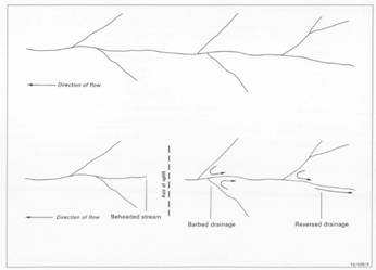 |
| From Ollier and Haworth (1995) The effect of uplift on a denritic drainage |
How did this come to be? Ollier and Haworth (1994) came up with a surprising solution. Essentially, they thought that the angles the tributaries were joining the Clarence would make sense if the Clarence River once flowed the opposite direction. Today this seems like a far fetched idea, I mean, water can’t run up hill, can it? But Ollier and Haworth (1994) thought that prior to the Cenozoic volcanoes that make up the Main Range, Focal Peak and Tweed Volcanoes the land surface would have been much flatter. Indeed the sediments closer to these volcanic centres has been uplifted by hundreds of metres. If there were no mountain ranges along the Queensland border it would be quite conceivable for a river to flow from the New England highlands northward into the Condamine River in Queensland and then into the Murray-Darling River system.
The current trace of the Clarence River is a little bit strange. In many places it crosses between hard Palaeozoic basement rock of the New England into the softer rock of the Clarence Morton Basin and then back again. Rivers usually cut river channels preferentially into softer rock and will rarely flow from gentle valleys in softer rock into steep hard valleys as the Clarence River does along its southward path. Combining this with the knowledge that parts of the Clarence Morton Basin have been shown through various seismic exploration techniques that is has been warped in various directions adds further to the argument.
I for one, am convinced. I think that the Clarence River once flowed north before the Macpherson Range came into existence and the River would probably have joined with an earlier Condamine River. Need to check for yourself? Have a look at the rivers of the region on a map, follow the route of the Clarence River from the Pacific ocean and observe the rivers that join in. Surprisingly, you might find it makes sense!
Postscript: Still can't picture the Clarence River flowing inland? This post discusses the location of the Great Australian Divide and where it would have been when the Clarence River flowed into the Murray-Darling/Condamine System.
References/Bibliography:
*Ollier, C., Haworth, R.J. (1994) Geomorphology of the Clarence-Moreton Basin. In Wells, A.T. & O’Brian, P.E. Geology and Petroleum Potential of the Clarence-Morton Basin. Australian Geological Survey Organisation, Bulletin 241.
Monday, 9 January 2012
A westward Wilsons River
The Wilsons River flows from east to west between Booyong and Lismore which is unusual for coastal rivers in the region. You’d expect a river to find the path of least resistance and head to the sea quite quickly, in the case of the Wilsons River the path of least resistance appears to have been away from that range of hills or mountains in the Alstonville area and away from the sea.
In his masters research, Cotter (1998) discovered that the landform of the tweed volcano was more complex than the simple shield volcano model proposed by earlier researchers. The shield volcano model essentially shows a radial drainage pattern from the centre of the shield a bit like the spokes on a bicycle wheel. While this does hold up well for the remaining skeleton of the Tweed Volcano of particular interest is the area to the south where a previously unidentified Cenozoic volcanic unit was discovered and shows that pre-existing structures explain the river drainage. Cotter (1998) suggested the name of Alstonville Basalt for the new Cenozoic (up to 41 Million Years old) unit as it appeared to pre-date the tweed volcano (23 Million Years). Additionally, it has been identified that the even older Mesozoic Chillingham Volcanics (but here consisting of basalts rather than the rhyolites that are seen further north) occur on what was once considered the southern flank of the volcano.
Brodie and Green (2002) observed that the dip of the Alstonville Basalt is to the north west which to me seems to indicate a volcanic centre further to the south east (in the opposite direction for lavas from the Tweed Volcano) assuming that not too much deformation has occurred since the rocks were erupted. Taken together this implies that during the Mesozoic hills existed to the south of the present day Alstonville Plateau and that during the early Cenozoic volcanic hills were emplaced and created a barrier for southerly or easterly discharge.
Cotter (1998) suggests that the Wilsons River has actually roughly followed its current path since the Late Mesozoic. The diatomite deposits located at Tintenbar and Wyrallah are of lacustrine origin and may be the result of lakes forming on the newly erupted Alstonville Basalt as the Wilsons River was intermittently impounded by the existing hills of the Chillingham Volcanics. It has been following a westerly course certainly before the Tweed Volcano (c. 23 Million Years) for the Chillingham Volcanics and Alstonville Basalt has stopped the Wilsons from flowing south or east. This continuity of flow direction implies that any lavas from the Tweed volcano would have cut through the Lamington Volcanics of the Tweed volcano unless the lava was of significant enough volume to change river direction. This volume of lava appears unlikely given the distance of this area from the centre of the volcano now represented by Mount Warning.
Putting all the background together shows that the section of the Wilsons River from Booyong to Lismore may have been flowing away from the sea for more than 40 Million Years, yet, additionally it is worth noting that the majority of the length of the Wilsons River, Richmond River and even Clarence River is north-south parallel to the coast. This implies some form of pre-existing structural control, probably associated with the deposition of the Clarence Morton Basin or even older Palaeozoic basement rocks, in turn; suggesting that the northern rivers have been following similar flow paths for a long, long time. However, this is a discussion for another post.
References/Bibliography:
*Brodie, R.S. & Green, R. 2002. A Hydrogeological Assessment of the Fractured Basalt Aquifers on the Alstonville Plateau, NSW. Australian Bureau of Rural Sciences, Australia
*Cotter, S. 1998. A Geochemical, Palaeomagnetic and Geomorphological Investigation of the Tertiary Volcanic Sequence of North Eastern New South Wales. Masters Thesis, Southern Cross University.
*Ferrett, R. Australia's Volcanoes. New Holland Publishers 2005.
Subscribe to:
Posts (Atom)